


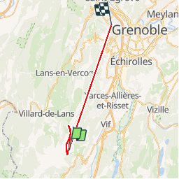
col vert de prelenfrey

Sylvie Mathiot
User

Length
31 km

Max alt
1750 m

Uphill gradient
2081 m
Km-Effort
62 km

Min alt
206 m

Downhill gradient
3172 m
Boucle
No
Creation date :
2019-09-01 07:22:59.235
Updated on :
2019-09-01 16:46:37.505
4h33
Difficulty : Medium

FREE GPS app for hiking
 SityTrail
IGN / Geographical institutes
SityTrail Plus
The world is yours!
About
Trail Walking of 31 km to be discovered at Auvergne-Rhône-Alpes, Isère, Le Gua. This trail is proposed by Sylvie Mathiot.
Positioning
Country:
France
Region :
Auvergne-Rhône-Alpes
Department/Province :
Isère
Municipality :
Le Gua
Location:
Unknown
Start:(Dec)
Start:(UTM)
704672 ; 4988492 (31T) N.
Comments